America’s Great Loop
America’s Great Loop is a long-distance inland and coastal cruising route that links the Great Lakes, inland rivers, the Gulf Coast, the Atlantic Intracoastal Waterway, and the Canadian/US inland systems into one continuous circuit. Most Loopers complete it over many months to roughly a year (or longer), typically traveling counterclockwise to align with weather windows and seasonal water levels. It is not a race route—it’s usually done in practical daily legs with weather days, maintenance stops, marina nights, and anchorage stretches. Planning matters: bridge clearances, draft limits, lock schedules, fuel range, insurance requirements, border/customs steps, and regional storm seasons can all shape timing and route choices.
Use this hub to move from broad planning to practical decisions: compare candidate boats, study stop sequences, then build a route you can actually live with day after day.
Core Great Loop planning guides
Start here if you are planning the Loop seriously. These pages are written as practical decision guides, not quick summaries.
Great Loop Starter Guide
The broad planning map: route, seasons, boats, budgets, bridges, locks, and mindset.
Route Overview
How the major regions connect and why route order matters.
Seasons
How to think about spring, summer, fall, winter, storm risk, and northern timing.
Budget Guide
Fuel, dockage, maintenance, insurance, provisions, and margin.
Boat Requirements
Air draft, draft, range, handling, layout, and maintainability.
Beginner Mistakes
The planning traps that quietly make the route harder.
Practical skills and boat-choice guides
Boats Under 40 Feet
Why smaller boats can make excellent Loop boats when the layout is honest.
Great Loop Trawlers
How to judge trawlers by route fit instead of reputation alone.
Bridge Clearance
Air draft, measuring, fold-down gear, and conservative bridge thinking.
Locks Guide
Roles, fenders, lines, waiting, commercial traffic, and calm habits.
Marina Planning
Fuel, reset stops, repairs, reservations, pets, weather waits, and backups.
Weather Planning
Go/no-go decisions, exposed water, fronts, wind, and schedule pressure.
How to use these Great Loop pages together
- Start with Loop Boats if you are still pressure-testing boat fit for draft, air draft, beam, layout, and guest comfort.
- Use Gold Loop Route and Platinum Loop Route to understand common stop order and route rhythm.
- Move into the Route Planner when you want to build a custom version around your start point, pace, and preferred stops.
- Use marina links, conditions pages, and local tools when the route starts turning into real departure decisions.
Start with one of these paths
I’m trying to choose the right boat
Start with Loop Boats, then read couples vs guests, boats by budget, and the pre-purchase checklist.
I’m trying to build the route
Start with Gold Loop, Platinum Loop, and Route Planner, then add stop strategy and seasonal timing.
I’m trying to lower daily stress
Read locks, bridge clearance, weather windows, and pacing without burnout.
Featured planning reads
How to plan a Great Loop season without rushing
A practical way to build a route around weather, crew energy, and real cruising days.
Best Great Loop boats for couples vs guests
How layout, privacy, and day-to-day workload change the right boat choice.
Chesapeake stopovers worth planning around
Why some Chesapeake stops work best for reset, service, weather, or staging.
Common first-time Great Loop mistakes
- Buying the route story instead of the day-to-day lifestyle: a boat can look perfect on paper and still feel wrong once you factor in stairs, docking workload, heat, laundry, and guest privacy.
- Underestimating weather delays: a realistic Loop plan needs waiting days for wind, thunderstorms, shallow-water timing, open-water crossings, and plain old crew fatigue.
- Optimizing for the rare hard week instead of the normal month: many people overweight one dramatic crossing and underweight the hundreds of ordinary docking, provisioning, and sleeping decisions that define the trip.
- Assuming every leg should be efficient: some stops are worth extra mileage because they reduce stress, improve maintenance timing, or create better positioning for the next weather window.
- Treating charts, marina lists, and route pages as fixed truth: the Loop changes with dredging, shoaling, closures, repairs, storm damage, local policy shifts, and season-specific conditions, so verification is part of the lifestyle.
Seasonal timing in plain English
Spring
Many crews use spring to move north, balancing river flow, lock timing, and the desire to avoid arriving too early in colder northern water.
Summer
Summer often favors Great Lakes, Trent-Severn, Georgian Bay, and northern cruising stretches where longer daylight and milder temperatures make slower exploration more rewarding.
Fall
Fall usually means working south again while watching hurricane season, shoulder-season marina patterns, and shorter daylight windows.
Winter
Winter plans often concentrate in Florida, the Gulf, or other warmer stretches where crews can slow down, reset, and decide how aggressively they want to keep moving.
There is no single perfect calendar. The real question is whether your route order matches your comfort with heat, cold, storm risk, crowds, and how fast you actually like to travel.
Where to go next based on what you need
I’m still choosing a boat
Start with Loop Boats, then read the couples vs guests guide so the boat search stays grounded in real use.
I need route shape, not boat shopping
Open Gold Loop Route, Platinum Loop Route, and the Route Planner to compare rhythms and stop logic.
I’m trying to reduce daily stress
Use marinas, anchorages, docking guidance, and anchoring basics together instead of solving each decision in isolation.
High-level route maps
Route segment guides
Use these pages when the big route idea turns into regional planning. Each segment has its own rhythm, risks, stop strategy, and verification habits.
Florida Segment
ICW rhythm, bridges, heat, storms, staging, and Gulf decisions.
Atlantic ICW Segment
Bridge schedules, shoaling, current, stop density, and protected-water pacing.
Chesapeake Segment
Bay weather, towns, anchorages, marina resets, and side-trip discipline.
Hudson and Erie Canal
Locks, air draft, canal status, town docks, and slower route rhythm.
Great Lakes Segment
Big freshwater, weather windows, harbor spacing, and northern timing.
Inland Rivers Segment
Current, tow traffic, locks, fuel spacing, debris, and tactical movement.
Gulf Coast Segment
Protected stretches, exposed legs, storm timing, staging, and weather waits.
Florida Big Bend Crossing
Weather windows, staging, boat readiness, crew rest, and conservative options.
These are editorial overview graphics, not navigation charts. They are meant to help readers compare route styles, start-point logic, and the basic shape of the trip at a glance.
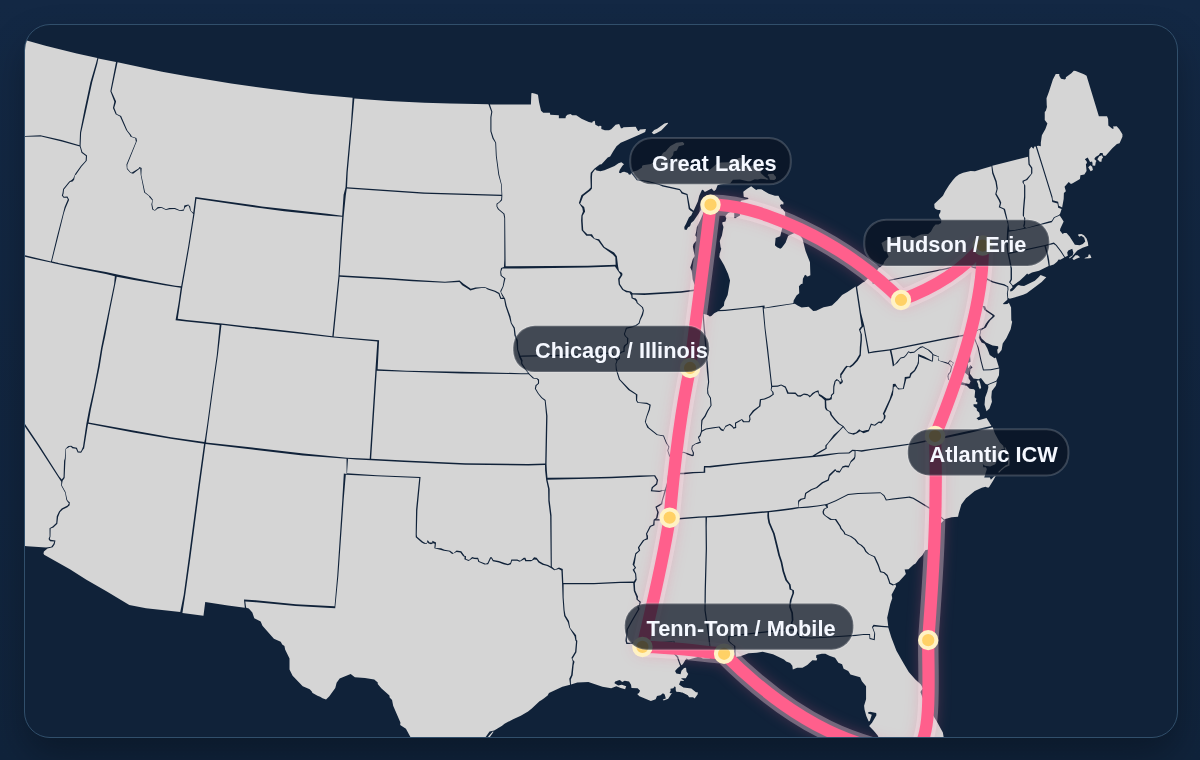
Classic Loop map
The standard high-level loop shape for broad first-time orientation.
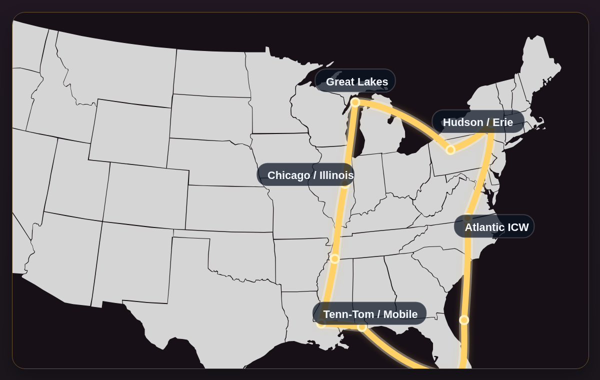
Gold Loop map
A simplified visual for the Gold route rhythm and how it differs at a glance.
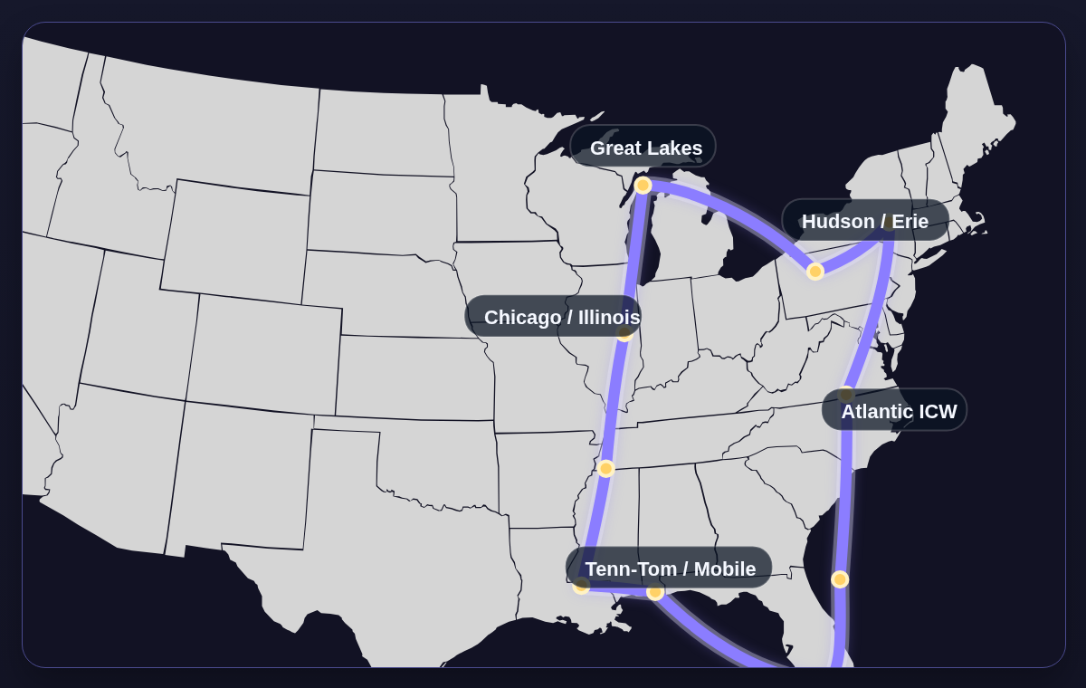
Platinum Loop map
A broader route-comparison graphic for the Platinum version.
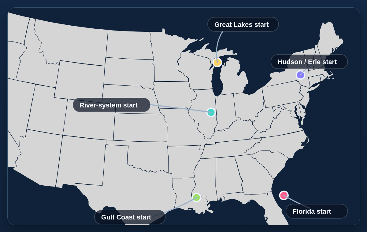
Start-point comparison map
Shows the common regions crews use to begin and what each start represents strategically.
Expanded planning library
Locks for first-timers
A confidence-building guide to lock days, lines, fenders, and crew roles.
Bridge clearance strategy
How to measure honestly and avoid low-bridge magical thinking.
Weather-window decisions
When waiting is smart, what exposed stretches punish impatience, and how to think clearly about go/no-go days.
How much the Loop really costs
The major budget buckets and which choices change the total fastest.
Choosing your start point
Pick the opening region that matches your season, confidence, and logistics.
Beginner mistakes
The common misunderstandings that quietly make the trip harder than it needs to be.
Boat-shopping and daily-life reads
Route rhythm and trip logistics
Core association resource
Hidden Gem Anchorages
Community-submitted anchorages with map links. Submit your own hidden gems below.
Boating Knots
See the full knot guide here: 20 Essential Boating Knots ↗
Important verification notice
Please verify all boat data, routes, bridge clearances, lock details, and waypoints before use. Mistakes can happen and information can become outdated. Always use current official charts, Notices to Mariners, and up-to-date navigation sources. If you find broken, outdated, or incorrect links/data, please report them so we can fix them.
Great Loop stop planning and boat decisions
These final planning guides answer the practical questions that come up once the route feels real: where to stop, how to refuel and resupply, when to use yards, and how to choose a boat that fits the trip.
Best Marina Stops
How to choose marina stops by fuel, rest, service, weather, provisioning, and staging value.
Fuel Stops
Range, reserve, dock hours, sparse stretches, and conservative fuel planning.
Provisioning Stops
Groceries, laundry, water, trash, pets, packages, pharmacy, and crew reset strategy.
Repair Yards
Service regions, haul-outs, mechanics, parts, records, and repair margin.
Anchorages vs Marinas
Use both stop types as tools for cost, comfort, safety, weather, and morale.
Catamaran vs Trawler
Beam, air draft, draft, comfort, marina access, and support tradeoffs.
Diesel vs Gas
Fuel type, range, maintenance, cost, availability, and real route fit.
Single vs Twin Engine
Redundancy, maintenance, docking, handling, range, and confidence.
How Big a Boat?
Length, beam, draft, air draft, comfort, cost, guests, and crew handling.
Trailerable Boats
Smaller-boat Loop strategy, road logistics, storage, ramps, comfort, and weather limits.